
This was the first search boundary. People have been searching far and wide since then and have posted maps of where they have been.
This is where it all started . If you click on the link it will take you to Josh's house near the Three Crowns at Little toke in Stone. From there you can zoom in or out to find the places mentioned on the maps that people have searched. I can't figure out how to highlight these areas as the link take you to Google maps and they don't want me scribbling over everything lol but I hope it helps that you can see where has been searched and where could do with a look. There is no harm in going over an area again as everyone looks in different ways and one person may see something someone else missed.
I hope you all find this useful.

I have put the maps people have shared on the facebook page with any posts and comments that have been made regarding that map. I have tried to find each location and include a link so anyone not familiar with the area will know where things are. When they post a list of areas covered I will put that on here and the home page so everyone knows which areas have been searched, having said that any area is worth going over again as each person looks in different ways and one person might see something that someone else would miss. I have tried to include everything but the group has over 8,000 members and keeping track of all that chatter is very difficult.
Josh lives where the blues dot is and went off to work on Tues 25/10/16 but never got there. He was reported missing at 6 P.M. and now hundreds of people are helping search for him. Putting maps on facebook of areas they have covered. but not everyone has facebook and one of those people may have seen something. Police are asking anyone who has a dash-cam, go-pro, helmet cam. cctv or anything like that and were in the area on Tues 25th to check their footage or hand the recordings to the police. case number 639 of October 25 th.

29/11/16
We have covered this area as best we can, checking out beech caves next


Searched the forests behind Hilderstone today
30/10/16
www.google.co.uk/maps/@52.9076433,-2.06426,1596m/data=!3m1!1e3

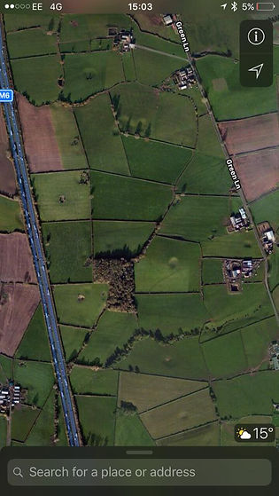
Wed 2nd Nov 2016
Area of Shugborough covered today. Spoke to a bloke on a quad who works there and is also checking. Halls closed. But he's also told the adventure/outdoor kids place to check around and in buildings.
this is Shugborough hall and surounding grounds.
www.google.co.uk/maps/@52.7994489,-2.0133266,477m/data=!3m1!1e3

We covered the woodland around the canal this morning, and the woodland nr the railway tracks towards the downs banks. We also walked through the woodlands to Meaford power station. We spoke to passers by and gave them the poster, and also left some on the canal boats. We went to the construction site at Meaford and spoke to some staff, gave them a poster and we also contacted the development managers via phone. The lady we spoke to said she was going to pass all the details on to the contractors working there so they can keep an eye out or possibly check the wooded areas they own. They were very helpful and supportive.
I hope we hear some news soon.
www.google.co.uk/maps/@52.9180955,-2.1664261,481m/data=!3m1!1e3

05/11/16
Searched this wood extensively this morning. Just NW of M6 Swynnerton. If you are up that way please be aware there is shooting going on today.
www.google.co.uk/maps/@52.9297662,-2.2144669,2327m/data=!3m1!1e3
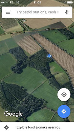
Wed 2nd Nov 2016
Also did this bit this morning while areas were being decided on and chosen. Spoke to some blokes working on the fencing and told them to keep eyes out.,
This is Stone business park, Aston roundabout. Stone.

I think this is the old disused railway in Stafford, now a popular cycle and dog walking route posted 31/10/16

This looks horrendous but Is actually the dense woodland around swynnerton covered today. 31/10/16
www.google.co.uk/maps/@52.9138308,-2.2129652,438m/data=!3m1!1e3


did anyone go to springpool wood? This is where me and a few other think we saw him yesterday??
reply
We will check it at some point (obviously if people are in area please do look) - it's incredibly unlikely that he's walking around (not impossible of course) so I'm struggling with this sighting a bit. Police are checking into it now xx
Thanks we 100% saw a guy sat in the trees. Close the the m6. My friend called 101 yesterday. I hope hes safe and sound x
I live on campus, right next to Springpool woods. Just got back from a long walk with the dog at the top half of woods. No sighting. Will look around the bottom half when I walk the dog tomorrow.
Just been in Trentham so iv'e Parked on Chase Lane Lane and taken a walk over to Bunbury wood. Anything to help Hannah although lights fading x
iv'e also rode through hem heath woods today but nothing x
all replies on the pictures post on 30/10/16


Beechcliff woods round the monument searched
30/10/16
www.google.co.uk/maps/@52.9468335,-2.1984871,1291m/data=!3m1!1e3

My friend Alex has searched today with the owner of the mooring and boatyard this area - they have checked every mooring, boat, building and outbuilding as well as the streams and any scrub or hedgerow or ditch they could find - they have spoken to all the regulars in that area on the towpath etc too - they are as sure as they can be he is not there currently and no-one they spoke to has sighted Josh around the area during the time he has been missing although again they are all on the look out. posted 01/11/16
www.google.co.uk/maps/@52.8061718,-2.0090287,957m/data=!3m1!1e3

this says it is Hatton bogs up the A51
Found this area just off the A51 so it's had a thorough search.
posted 31/10/16
sure looks as though they gave it a good going over.
www.google.co.uk/maps/@52.9289493,-2.2659931,1133m/data=!3m1!1e3

01/11/16
We have covered this area of sandon hall, some of it private ground. Also spoken to games wardens and the estates manager, and estates officer. They have taken posters, will tell all their staff and email anyone they know and ask for cctv also. There is a shoot in the yellow area so they will also be contacted as they have dogs too. They have our details and I have details for the estates officer, so can contact us if nothing found but will contact police if anything is found
www.google.co.uk/maps/search/52.856020,+-2.065058/@52.8531958,-2.0700357,15z

14/11/16
Hi, walked this area on friday morning, apologies for the late picture upload
www.google.co.uk/maps/@52.9240158,-2.2324792,2493m/data=!3m1!1e3


posted 1/11/16
I assume the red areas are bits that he has searched, wooded areas by the look of it.
Hopton heath
I don't know when this was posted but someone has covered this area.
Springpool wood

posted 01/11/16

14/11/16
Had these walls sent to me today, can we update the map please. Also there is a CCTV point too x


posted 01/11/16
52.772029, -1.967827
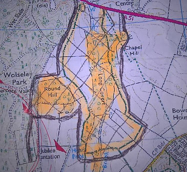
posted 31/10/16
wooded land off the A51
52.887387, -2.127603


14/11/16
We ran this on Sunday. I expect this route to be used regularly with dog walkers? And maybe already searched? Kept our eyes peeled but nothing. So sorry x Btw Has the plume got cctv onto the canal? Hopefully tomorrow's canal walk will bring new hope


Thanks to Cathy - This is (approx) Josh's walk on 25th October, up to latest CCTV of MG Sanders.
Let's say for arguments sake he got to where he wanted to be in the same day ..... so how far could he have walked ?
I no this is obvious but might give a clue on radius for search
If that makes sense ?
From what I've gathered. He was very fit, so could have walked all day. However, he had breakfast but didn't take his lunch with him. So I'd say half a day walking at the most.
I'm just thinking about his mind set etc it could be possible that where he planned to go that he would reach there before it went dark ...as these rural areas are very badly lit away from the main road ...
Just trying to think how far he could of reached in the time scale etc and before nightfal
I suppose it's possible that he didn't have a location in mind at all. He could of just taken off with the plan of finding a suitable place on route?
I don't know the canal well but could Josh have gotten off by the little hump bridge on Newcastle Road and walked down towards the BP. Might this tie in with the potential sighting on Meaford Rd by I suppose he could have caught a bus as there are stops both sides of the road in Newcastle Road not too far along by Fox's car sales...


05/11/16
Areas covered so far today, fields between canal and river, river and A34
52.901503, -2.154434
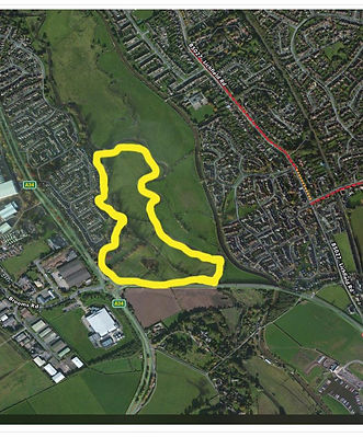
This is Stone cemetery and behind Cherryfields up to the river. posted 31.11.16


Last searched area for today, got too dark to finish. I can carry on here tomoz or head toward south of stone to help there xx
I've superimposed the area I looked through this evening in yellow - tried to get deep into undergrowth but a lot of land to cover and became too dark to safely / effectively continue.
Like · Reply · 3 · 31 October at 21:17


31 October near Swynnerton ·
We've just been to Beech Caves and searched in the caves. Nothing there.

We have covered this area today (black crisscross section) - lots of woodland and fields.
This was posted 31/10/16. I don't know if any of it was covered.
URGENT: We need volunteers willing to go and cover the pink highlighted little woods on the map. Ideally before the sunset. It is the area adjacent to the M6. If you are available please contact me as soon as you can. Thanks
I could but I'm not available till 6 because of the kidlets but if all else fails give me a message xx
At Springfield - coming in from under motorway
Irene says if poss concentrate on other side of m6 as we have done this. But depends where you are heading
We have just left woods
Just pulling out of Springfield back to MWay - will try to look other side but light is fading fast...
I did the little section just by the motorway but was just full of rubbish. There's so many areas that one could hunker down and hide though throughout the woods, map shows area I did right side perimeter edge of woods to ponds and ditches on right side down to M6

05/11/16
We did this area off A34 down off Aston Lane this morning. Colleagues were continuing on to Burston when I had to leave. We also searched the perimeters of the two fields to the left of the red and green dots just forgot to turn on the app. There was a large haystack in the large field which we also checked.
Thanks Jodie we carried on checking other fields south of the pond, checked a wooded area and then followed the river back to Aston. We met Search and rescue out with a dog searching the pond and river area. Xx

05/11/16
Did some surrounding fields too but gps failed me
We didn't see any posters until we got to the burston - stone track. Could anyone nearby stick some up?

05/11/16
Has anyone searched this area behind The Trentham Estate. It is a public right of way and can be accessed from the road at the side of the poachers cottage on the a34 or from the Eccleshall Road. I don't know Joshua but I hope he is found soon. My thoughts are with you all
Sorry. Just read your pinned post and think it's already been done

05/11/16
Our search area today. Sorry it's late appearing.
Can you confirm how thorough this was searched plz
It was done with nine of us in the group. But it's a massive area and, at times, difficult, steep, full of bracken. It absolutely should not be ruled out by anyone else. When you get on the ground there it will quickly be understood that 9 people will only see a fraction of what is there.
Thank you for replying. I can imagine how difficult this area would be to search. we are going to research that area tomorrow.
Did you stay close to the public footpath? X
I wish you well. No, we specifically focussed on areas away from any footpath. In the bottom right hand corner of the shaded area, about 100yds in from the A51 is a large area where a large wood has been cleared. It has very deep ploughed lanes. We spent an hour sweeping this area only to be told later by a local resident that it had been cleared a few days after Josh went missing. Therefore don't linger or waste time on it.
OK thank you for the information X
I agree with Rachel. It would definitely benefit from another look around as it is huge in there. And very dangerous in places. So please don't go alone and take great care xx
I can help on Monday if needed x

Just going through maps. I can't see on any posts if meaford hall area in blue had been searched. X
I'm sure Meaford Hall is private land, big wall all around and electric gate to gain entrance...
Like · Reply · 14 November at 14:18
I do however know it is covered with CCTV which may have footage out of the grounds.
Like · Reply · 14 November at 14:26
Emma Barnett thanks. Has this cctv been considered I wonder?
Like · Reply · 14 November at 14:27
I'm not sure... I've only just remembered it was covered with CCTV with you mentioning it.
Like · Reply · 14 November at 14:28
I know there is a camera at the gate, but I don't know if that's there just for when you want to gain entrance or to record all day long.
Like · Reply · 14 November at 14:29
i was wondering this today also if had been searched and if under the bridges that go over the river on the darlaston roundabout. Also on a34 going from stone to darlaston is a bus stop with very overgrown area leading down to the river??
Like · Reply · 14 November at 20:22
I may be able to find out who owns it as I know the previous 3 owners and they're quite a close knit group so I will ask them. There is a nice, secluded wooded area at the bottom so if it hasn't been checked that'd be where I'd start. It's not as big as most people think as a lot of it is built up

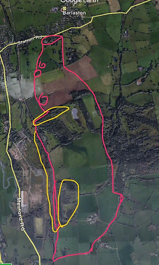
06/11/16
Route today, from canal to downs bank, Barlaston to another footpath back to canal. Areas in yellow possible further search areas but need more than one person. The area to the left of the canal is easily accessible between bridges 100-101 as the fencing has been broken down. Lots of undergrowth and trees, and ends by a quarry but definitely needs a group to effectively search.
Also spoke to a ranger at downs bank who was aware as he also works Shugborough. Gave flyer, said he'll keep an eye out for josh and anything that could be related x

06/11/16
I went around this estate (all areas within the lines) & handed out posters. There's a high level of awareness on this estate so did not go door to door but did cover most areas. Everyone I spoke to knew about the search for Josh. Some had seen posters in local pub, couple ppl following ths group too.One property along the canal had cctv-asked lady there to review Tuesday if available & use contact details from poster. One lady said she would put poster on boat so more ppl see. Sorry not much but hopefully better than nothing.

06/11/16
Covered the farmland and wooded areas off the canal yesterday.
06/11/16
Has anybody searched the old building next to trentham church? Joined to trentham gardens?

Covered this area of Barlaston Downs at the weekend, down into the bracken off the main paths with the dog... Some parts were very thick - we all said it was an ideal place for someone wanting to hide, but still many areas to cover.
posted 07/11/16

10/11/16
Today we have walked some of park hall with Lottie the dog. We basically followed the blue track and went off the beaten track on either side looking through bushes etc unfortunately nothing to report 😞
We have also put some laminated posters up at park hall. X
Sorry my map isn't too good x


10/11/016
Done this today. I know it's probably been covered numerous times but fresh eyes never hurt. Took the route josh last seen then over and round church and grounds.
Not gonna give up looking....
At the bottom of the church grounds was a derelict building with the door ajar. I shall admit that I was too scared too enter. If anyone braver could have a check or has it been checked??
Aston.s.Saviour church it was right at the back down a ditch. I don't mind meeting more people tomorrow?
Not sure if this has been suggested but me and my mum have been thinking tonight and were wondering if anyone had checked what we used to call "the common", down common lane in Meir Heath. I haven't been down for years but when we were younger we used to go there as it was secluded woods/old quarry, and not sure if you can access other fields through that way? May be stupid but had to suggest.


13/11/16
Today three of us have walked from Trentham to just past the plume of feathers. Put up posters along the way. We have checked every path off the canal and every little track off route.Big field perimeter also checked. The rest is either people's gardens or not accessible. We crossed over by the locks also and checked the other side.
There are two houses that back onto the canal and they have CCTV in their back gardens. I shall try and find on the map where the front entrance to these houses are as they was no one about in the gardens as we passed.
There were so many people searching today, groups, couples, dog walkers. Met so many people you could clearly tell were out searching.
Josh will be found soon with the continued support of our lovely community 😊 keep up the support x
www.google.co.uk/maps/@52.9558547,-2.1777548,1904m/data=!3m1!1e3
Using your photo we have walked the yellow line of canal daily, and can see the yellow shaded field next to canal from our house and walk around the other daily, this one is next to a footpath that is accessed from old road Barlaston towards the back of Bassets crossing the river.


13/11/16
Area to the right side of downs bank this morning, still more to finish this section but went on to Moddershall.
will update that area later x
www.google.co.uk/maps/@52.9265952,-2.1460245,1906m/data=!3m1!1e3


My son and I searched the area within the yellow box. Meaford road to the left up to Washdale lane at the top and the canal on the right. We walked through the field and the wooded area. We intend to go back with a torch and check the tunnel under the canal and road. Our dogs didn't find anything unusual, the area does not appear to be well walked and nothing looked out of place except a black jacket hanging on a post.
Hannah says the jacket is not Josh's.

13/11/16
..circled is Meaford bridge by Meaford locks.. he could have taken a right turn here..taking him onto Mount rd...or if he went left (over the bridge circled in red) through the fields it would bring him out Meaford rd..by new roundabout..just before George n Dragon.
13/11/16
Sorry it's late. Today's search areas at Moddershall to add to Shazzer Sleazy Lees' post earlier. Area 1 is larger than one would think and there are plenty of lovely peaceful spots. Area 2 is vast and full of spruces. If Moddershall becomes a likely option once new CCTV options have been reviewed, both areas could do with another look with greater numbers of folk. Moddershall Oaks woods is privately owned but we have got his phone number, so that is one to do another time. The woodland marked Idlerocks is owned by a private property with high wire fencing all around. Another great bunch of seachers, top people (and dogs) all. Also really lovely to see Mary Leese and Audra Jones at the 3 Crowns, albeit too briefly before they went off to tackle the Downs Banks.
Large Heading


01/11/16
After TinkerElle thought she saw Josh yesterday I have had a look on Google maps of the area between Yarnfield lane and Eccleshall road. The only obstacle in Josh's way is the railway line, however, I have circled a possible place where Josh may be able to cross or go under the train lines. Maybe worth a check...

01/11/16
Searched the woodlands in the states area and we are now down by the railway line where there is a small tunnel and a wire fence. Not a lot to stop people from crossing the line.


